Save Warner Springs – NEW #2

Save Warner Springs

Keep the line off Scenic 79

San Diego Backcountry says NO to the SDG&E Golden Pacific Powerlink

SDG&E wants to run a 500,000-volt transmission line up the Highway 79 corridor through our valley. We are neighbors, ranchers, vintners and families who oppose it, and we are asking the California Public Utilities Commission to take this route off the table.

PHOTO SLOT 1 · Hero
Valle de San José at golden hour, Hot Springs Mountain behind
The heart of the backcountry

A valley that still looks the way it did

Warner Springs sits at about 3,200 feet in the historic Valle de San José, below Hot Springs Mountain, the highest peak in San Diego County. This rural backcountry holds the headwaters of two major watersheds: the San Luis Rey River, which runs west to the ocean at Oceanside, and the Santa Margarita River, fed by Temecula Creek, which reaches the sea at Camp Pendleton. Oak woodland, open grassland and granite ridges run to the edge of the Cleveland National Forest and the Los Coyotes Reservation.

People come here for what has disappeared from most of Southern California: quiet roads, dark skies, cattle on open range, and the picturesque small family wineries of the North Mountain Wine Trail, one of which has been here since the 1940s. Hikers and riders come for the trails through the Cleveland National Forest and Bureau of Land Management lands, and the Pacific Crest Trail passes right through town. The history runs deep along Highway 79, too. The Oak Grove Butterfield Stage Station, a stop on the 1858 Butterfield Overland Mail route, is both a National Historic Landmark and a California Historical Landmark.

This is living habitat, too. These hills are wildlife movement corridors that connect protected lands, from Palomar Mountain and the Cleveland National Forest to the ranges to the east. Residents know the Oak Grove area along Highway 79 as a crossing for our threatened mountain lions, along with bobcats and other wildlife. Much of this land is already protected: the Oak Grove Unit of the San Felipe Valley Wildlife Area is managed by the California Department of Fish and Wildlife, and the state has invested millions of dollars to protect it and keeps expanding it with new purchases. The upper San Luis Rey River basin includes designated critical habitat for the endangered arroyo toad, and other rare species, such as the endangered Quino checkerspot butterfly, survive in only a few places in inland Southern California. Ancient oaks, some of them centuries old, shade the creeks and pastures. A 500 kV corridor of towers, access roads and cleared right-of-way would cut through all of it.

Where the route runs

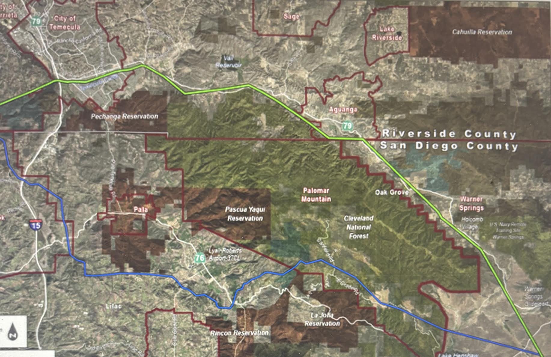
SDG&E map of the Golden Pacific Powerlink's preliminary route from Temecula past Aguanga, Oak Grove and Warner Springs toward Lake Henshaw
Tap a yellow marker to learn what the route passes. Drag to move around; use + and − to zoom.
  • Green: SDG&E's preliminary route along Highway 79 through Warner Springs
  • Yellow: Highway 79
  • White: roads that join Highway 79

Base map: SDG&E's preliminary routing map. The route is preliminary and may change. To see how close a specific property is, use our address map or SDG&E's interactive map.

Who lives here

A small, rooted community

About 1,500 people live across roughly 220 square miles of ZIP 92086. Many are retirees, ranching families and people who have spent decades here. Warner Unified School District serves local kids, and the community center on Highway 79 is where we meet, celebrate and organize.

A rural place like this has no city council to fight for it. The decision sits with state regulators in San Francisco, so our voices have to carry.

First people of this land

Kúpa and the Cupeño

Long before it was called Warner Springs, the hot springs were the village of Kúpa, home of the Cupeño people. In 1903 the Cupeño were evicted from their homeland and moved to Pala, a removal remembered as their Trail of Tears. Their descendants are members of the Pala, Los Coyotes, Morongo and other bands today.

The Los Coyotes Band of Cahuilla and Cupeño Indians lives on the reservation in the hills just east of the valley. These are cultural landscapes, not empty land.

We do not speak for any tribe. Tribal governments speak for themselves in this process.

Small family wineries

The North Mountain Wine Trail

High-elevation vineyards along Highway 79 grow on mineral-rich soil with cool nights. They are small, family-run and depend on visitors who drive up for the views.

Each of these wineries sits within about half a mile of SDG&E's preliminary route through Warner Springs. Here Highway 79 runs through a narrow corridor with mountains on both sides, so noise and dust have little room to spread out. Building a line this size typically brings helicopter work, heavy trucks, traffic delays and cleared work areas, and construction could go on for months or longer. That makes a quiet afternoon at a tasting room a much harder sell, and for small family businesses that depend on visitors, even one lost season matters.

Watch and share

See what's at stake

Share these with two neighbors. Short clips travel farther than any flyer.

VIDEO SLOT 1 · Feature video: the valley and its people
Oak Grove firefighter speaks out
Watch on YouTube
VIDEO SLOT 2 · Drone flyover along Highway 79
VIDEO SLOT 3 · Neighbor voices
The project in plain terms

What is the Golden Pacific Powerlink?

The Golden Pacific Powerlink (GPP) is a proposed 500-kilovolt transmission line that SDG&E would build, own and operate. It would run about 145 to 150 miles from SDG&E's Imperial Valley Substation to a new substation near the San Diego–Orange County border, by San Onofre.

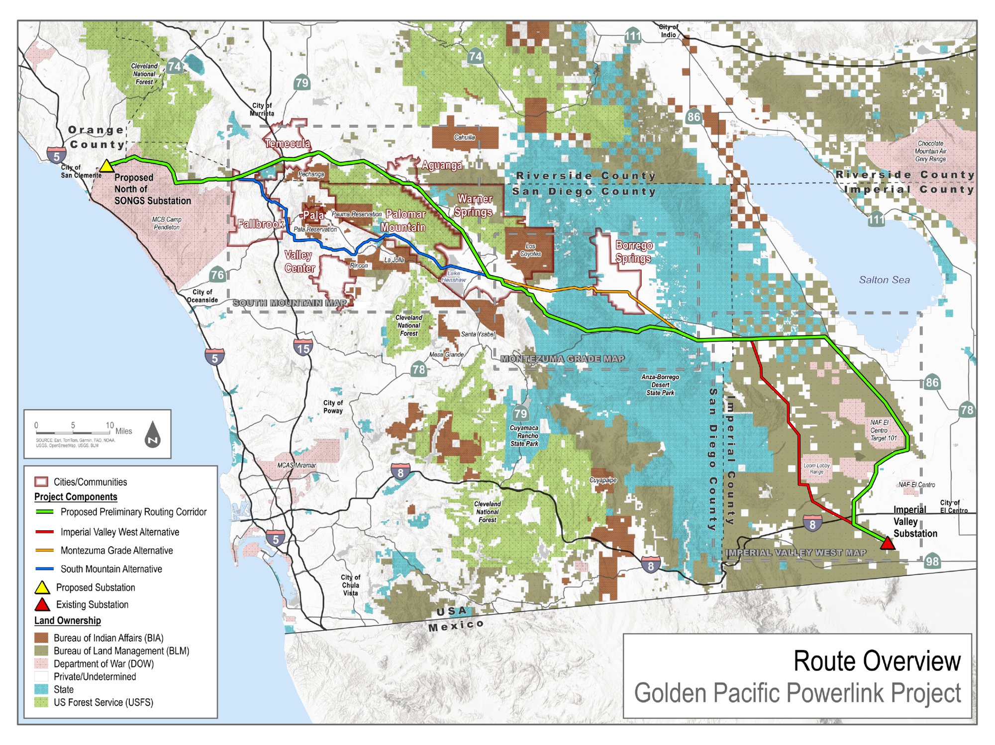
The state grid operator (CAISO) approved the need for the line in 2023. SDG&E's preliminary route crosses Anza-Borrego Desert State Park and then turns north along State Route 79 through Warner Springs, toward Lake Henshaw and Palomar Mountain. SDG&E has also mapped three alternative segments: Imperial Valley West, near the start in Imperial County; Montezuma Grade, which runs south of Borrego Springs; and South Mountain, which runs west from near Lake Henshaw past Pala toward Fallbrook.

The line is built to move power between the desert and the coast, toward Orange County and the Los Angeles Basin. Warner Springs would carry the towers and the risk while the power flows elsewhere.

500 kV500,000 volts, extra-high voltage
~200 ftSteel lattice towers, about 20 stories
145–150 miFrom Imperial Valley to the coast
$1.6–2.3 BPublished cost estimates; ratepayers pay
A 200-foot tower drawn to scale beside a 60-foot valley oak and a 25-foot two-story house 200 ft 100 ft 500 kV tower · ~200 ft Valley oak · ~60 ft 2-story house · ~25 ft

Drawn to one scale. Tower height as reported for this project; oak and house are typical sizes.

Where the decision stands · as of October 2026
  1. Spring 2023CAISO approves need
  2. Summer 2026SDG&E open houses; route & alternatives shown
  3. Nov–Dec 2026SDG&E files with the CPUC
  4. +30 daysProtests due; public comment opens
  5. 2027–2029Environmental review and CPUC decision
  6. 2032SDG&E's target in-service date
How it would change day-to-day life

Living beside a 500 kV line

This isn't an abstract grid project. For the next half-century, it would shape what we see out the kitchen window, whether we can insure our homes, and how we get out when fire comes.

Fire danger

Much of the Warner Springs area is mapped by CAL FIRE as high or very high fire hazard. Cal Fire found SDG&E power lines started the 2007 Witch, Guejito and Rice fires. In July 2026 a fire burned nearly 700 acres near Warner Springs, close to where the line would run. High-voltage lines can also restrict where air tankers and crews can work.

Insurance and home values

Fire insurance is already hard to get and keep in the backcountry. Added ignition risk, towers in the view and the stigma of living near a high-voltage line can push premiums up and property values down.

Highway 79 is our main way out

Years of construction traffic, lane closures and heavy equipment on the road we use to evacuate, get to work, reach a hospital and bring visitors in.

Views and dark skies

Towers about 200 feet tall along our ridgelines and riparian corridor, with aircraft-warning lights possible at night under our dark skies.

These skies are dark enough that Caltech's world-renowned Palomar Observatory sits on Palomar Mountain, just above this valley.

Noise and fields

500 kV lines crackle and hum, louder in wet weather. They also create a magnetic field near the line. The World Health Organization's cancer agency classifies these fields as a "possible" carcinogen, though the evidence is limited.

History and culture

The route threatens the setting of the Warner-Carrillo Ranch House, a National Historic Landmark on the old emigrant and Butterfield stage route, and landscapes sacred to the Cupeño and Cahuilla people.

Our local economy

Warner Springs depends on visitors and property taxes: small family wineries, ranches, and hikers on the Pacific Crest Trail. Visitors drive up for the view. Steel towers take that away.

Our well water

Many homes, ranches and vineyards here rely on wells and groundwater. Tower foundation work, which can involve deep drilling and sometimes blasting in rock, along with the large volumes of water used during construction, could lower water levels, cloud wells with sediment, or let drilling fluids and fuel reach the aquifer.

It isn't only our water. Vista Irrigation District owns the 43,000-acre Warner Ranch and pumps groundwater from its Warner wellfield to supplement Lake Henshaw, part of the supply for the roughly 135,000 people it serves in Vista and parts of Escondido, Oceanside and San Marcos. Under the San Luis Rey Indian Water Rights Settlement, water from this river system is also shared with the City of Escondido and the La Jolla, Pala, Pauma, Rincon and San Pasqual Bands of Mission Indians.

SDG&E's preferred route runs through Vista Irrigation District's Warner Ranch land. In October 2026, the VID board voted to oppose the Golden Pacific Powerlink because of the harm it could do to this water supply during and after construction.

Protect your well now: if your property is within about 1,000 feet of the proposed route, consider hiring a licensed local well professional to measure your well's static water level and a state-certified lab to test your water quality. A professional record made before construction gives you a baseline in case it is ever needed. Residents can ask the CPUC to require SDG&E to pay for independent monitoring of wells near the route and to provide replacement water if a well is harmed.

Land, ranching and eminent domain

A right-of-way hundreds of feet wide through ranches, vineyards and riparian habitat. Utilities like SDG&E can use eminent domain to acquire right-of-way for approved projects. Know your rights: California law limits entry onto your land without your consent or a court order.

How many properties? We traced SDG&E's preliminary route from the Aguanga area through Warner Springs and checked it against county parcel records. As traced, it crosses about 118 parcels, about 40 of them with a home on the assessor's roll. Another 213 parcels, about 80 more with homes, lie within 1,000 feet, along with two mobile home or housing communities. The route is preliminary and our tracing is approximate, so these counts will change as SDG&E files more detail.

What a taking usually means. For a transmission line, a utility usually takes an easement rather than the whole property. You keep the land but lose much of the right to build, plant or graze under the line. A home inside the right-of-way could have to be moved or bought out.

Will owners get fair market value? The California Constitution requires “just compensation,” meaning the fair market value of what is taken, plus damages if the rest of your property loses value. But the first offer is based on the utility's own appraisal. Owners can hire their own appraiser, negotiate, and take the amount to court if they disagree. In a 1988 case brought by SDG&E itself, a jury awarded a landowner about $190,000 for the land taken and more than $1 million for lost value to the remaining property, and the court allowed evidence that buyers' fear of power lines lowers property values. Neighbors whose land is near the line but not crossed by it generally receive nothing, even if their home loses value.

This is general information, not legal advice. If SDG&E contacts you about an easement, talk to a lawyer before you sign anything.
Before the line is even energized

What to expect during construction

Building a 500 kV line takes several years. Based on how projects like this are typically built, here is what that could mean for Warner Springs:

  • Helicopters. Helicopters are commonly used to set tower sections and string wire, which can mean repeated low-altitude flights and noise over homes, ranches and livestock for weeks at a time.
  • New access roads. Dirt roads graded or widened to reach each tower site, through grassland, oak woodland and creek crossings.
  • Heavy equipment on Highway 79. Cranes, concrete trucks and flatbeds hauling steel, plus lane closures and flagger stops, on the road residents already drive long distances on every day for work, school and services.
  • Clearing and erosion. Vegetation removed around towers, roads and work pads, leaving bare soil that can wash into creeks during winter storms and needs years of erosion control and revegetation.
  • Staging yards. Large yards for equipment and materials, plus helicopter landing zones and wire-pulling sites, all disturbing ground beyond the right-of-way itself. Sites near the Temecula Creek riparian corridor would add to habitat loss there.
  • Water use and dust. Large amounts of water for dust control and concrete, and dust from graded roads and pads during dry, windy months.

How loud is construction, next to a quiet valley?

Typical sound levels, in decibels (dBA). Every 10 dB increase sounds roughly twice as loud, so a drill rig at 84 dB sounds about 15 times louder than birdsong at 45.

SoundAboutLevel
A quiet night in the valley30
Light breeze in the oaks40
Birdsong45
Normal conversation60
Loaded flatbed or dump truck75
Crane or concrete truck80
Drill rig boring tower foundations84
Jackhammer or rock breaker89
Blasting rock (if used)94
Heavy-lift helicopter, about 300 ft away95–105
Impact pile driver (if used)101

Equipment levels are typical figures measured 50 feet away, from the Federal Highway Administration's construction noise model; the helicopter figure is for a heavy-lift helicopter about 300 feet away. Blasting and pile driving may not be needed at every tower site. Nature sounds are common reference values. These are general comparisons, not measurements for this project. Sound fades with distance (about 6 dB each time the distance doubles), but in a narrow valley walled by ridges it can carry and echo.

SDG&E has not yet released construction details for this route. They will be in its CPUC application and the environmental review, and that is when we can push for limits.

SDG&E's own maps

Where the line would go

These are the official maps SDG&E has published for the project. The route is preliminary and SDG&E says it can change, which is exactly why our letters matter now. Open the full-size versions on SDG&E's site to zoom in on Highway 79.

SDG&E's Route Overview map of the Golden Pacific Powerlink with alternatives. The green preliminary routing corridor runs from the Imperial Valley Substation near El Centro west across Anza-Borrego Desert State Park, north past Lake Henshaw and through Warner Springs, northwest past Aguanga and Temecula, and west to a proposed substation near San Clemente. Three alternatives are shown: Imperial Valley West (red) near the start in Imperial County, Montezuma Grade (orange) south of Borrego Springs, and South Mountain (blue) running west from near Lake Henshaw past Pala toward Fallbrook.
SDG&E's Route Overview map: the preliminary routing corridor (green) and three alternatives, Imperial Valley West (red), Montezuma Grade (orange) and South Mountain (blue). Tap the map to open it full size. Source: SDG&E.
What you can do this week

Take action

SDG&E expects to file its application with the CPUC in November or December. Once it does, a 30-day clock starts for formal protests. Letters sent now go into the record SDG&E files and put the CPUC's environmental team on notice about Warner Springs.

  1. Send a letter

    Use the template below or write your own. Two personal sentences matter more than two pages.

  2. Donate

    Our legal team can only represent Warner Springs as an intervenor in the CPUC case if we fund them.

  3. Document your well

    If your property is within about 1,000 feet of the proposed route, consider hiring a licensed local well professional to measure your well's static water level and a state-certified lab to test your water quality. A professional record made before construction gives you a baseline in case it is ever needed.

  4. Bring two neighbors

    Send this page to two people on your road. Our goal is a letter from every address.

  5. Show up in yellow

    Wear your yellow shirt to Sponsor Group, Board of Supervisors and CPUC meetings.

Letter template

Fill in, then copy

Your letter updates as you type. Nothing you enter leaves this page.

Concerns to include
To: public.advisor@cpuc.ca.gov Cc: GPP@ascent.inc (CPUC environmental review team) Or mail to: CPUC Public Advisor's Office, 505 Van Ness Avenue, San Francisco, CA 94102 Subject:

Paste into your email app. Highlighted text is what you still need to fill in. To mail a paper copy: CPUC Public Advisor's Office, 505 Van Ness Avenue, San Francisco, CA 94102.

Writing your own

What makes a letter count

  • Say where you are. Give your address or parcel and how far you are from Highway 79.
  • Be specific. Your well, your grove, your animals, your evacuation route. Specific facts must be addressed in environmental review; general objections are easy to set aside.
  • Name the project and the route. "Golden Pacific Powerlink, preliminary route along State Route 79 through Warner Springs."
  • Make a clear ask. Remove this route from the application, study non-wire and underground alternatives, and add you to the landowner notice list.
  • Stay factual and civil. One page is plenty. Personal and calm reads as credible.
  • Keep a copy. You may want to file it again as a public comment once the CPUC case opens.
Who to write
CPUC Public Advisorpublic.advisor@cpuc.ca.govPuts your comment in front of the regulator
CPUC environmental review teamGPP@ascent.incConsultant preparing the CEQA review

Find your state senator and assemblymember at findyourrep.legislature.ca.gov.

Many hands

Yes, I want to help

Every skill helps, and an hour here and there adds up. Check anything you might do. Your note goes straight to our team's email, and we'll get in touch.

I could help with

This opens an email to savewarnersprings@gmail.com with your answers filled in. Just press send.

Stay in the loop

Newsletter

Deadlines on this project move fast. Our newsletter tells you what changed, what's due and where to show up, in a few minutes of reading.

Latest updates
  • Save Warner Springs website launches

    Our new home for facts, maps, the letter template and ways to help. Share it with two neighbors.

  • SDG&E expected to file with the CPUC

    Once SDG&E files, formal protests are due within 30 days. Watch for our alert with the case number.

  • Community meeting

    Date and place to be announced. Wear your yellow shirt.

Click any date, headline or summary to post a new update.